A little about OpenStreetMap
01 Sep 2020OpenStreetMap (OSM) is an open source project with over 1 million contributors. It was conceived in 2004 & is now one of, if not the, best mapping resource in the world (Nick’s viewpoint!).
Nick has been involved in updating OpenStreetMap since 2008.
Nick
‘I grew up using Ordnance Survey Maps, and had complete faith in them. I also used other paper maps on occasions, but I started to realise there were limitations. On one occasion Daphne & I bought the latest OS map of an area for a holiday, and also invested in an electronic version to use on our Palm PDA’s. We went on several walks and cycle rides, but were disappointed when we found that both were out of date, leaving us stranded the wrong side of barbed wire fences or cycling along busy dual carriageways that didn’t even appear on the maps.
I got involved in OSM because it was interesting, and although there were initially many errors in the mapping, that made it no better or worse than the maps I had bought. At least with OSM I had the opportunity to correct the errors, and add the data.
I can remember a holiday in Germany where we had an OSM map on our Garmin, and I realised that every street in the remote village we were passing through had its name on OSM, the shops were all shown, together with their opening hours, and in fact the whole area was beautifully mapped. It gave me the incentive, when home again, to make sure my area was mapped with as much detail as possible.’
A few examples of OSM use
- Mobile phone navigation, including Osmand, Maps.me, Cyclestreets, MapFactor Navigator, Navmii GPS
- The British Red Cross, Medecines Sans Frontieres (Doctors Without Borders), American Red Cross and many other charities. (See https://www.missingmaps.org/ for more info and a full list of charities who are encouraging volunteers to map needy areas).
- As well as basic map usage for navigation, GIS experts are able to provide information to charities - population estimates, drinking water sources & possible problems, likely mosquito areas (helpful when working towards reducing Malaria).
- Maps are available in Garmin format, making up-to-date maps available for all of the world (quality can vary, but that should be understandable really!).
- Some delivery drivers & firms use the data (Amazon have a team of ‘mappers’ adding data to OpenStreetMap).
- As its an open source project, there are opportunities for computing study students to learn, add to, and prove themselves in an environment that encourages participation.
- The base map for many sites such as Strava and Geocaching.
Research resources for OpenStreetMap
 https://www.openstreetmap.org - the main page. If you would like to get involved, then create your login account here. Make sure you click on the layers icon on the right side of the screen to get an idea about how the same data can be transformed to appear differently.
- https://wiki.openstreetmap.org/wiki - The when, where, how & why of OpenStreetMap. It’s a terrific resource & worth investigating.
- https://learnosm.org/en/ - Translated into many languages, this site aims to help you get started with OpenStreetMap. If you are completely new to OSM, then reading the Introduction & OpenStreetMap.org modules of the beginner section should help you to understand more. Nick is biased as he contributes to this site.
- You may find a few entries on this and other sites that help you to get started. Personally I’ve found that learning and then using have given me enormous satisfaction - Nick. Make sure you click on the ‘hamburger’ icon top left to access the menu on this site.
Getting involved
Head over to https://www.openstreetmap.org and login - you may need to create an account, and you will have to supply an email address. Make sure you read the advice about contributing - we cannot copy from other people’s maps, except if they have given express permission, or the maps are so old they are out of copyright.
Uploading GPS traces
GPS traces on 01/09/2020
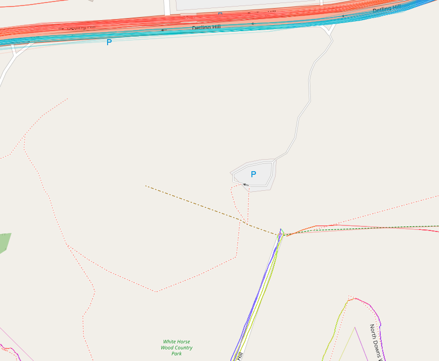 Once you have your account, perhaps you could upload a GPS trace? This link https://www.openstreetmap.org/#map=17/51.29703/0.59188&layers=G shows OpenStreetMap for the White Horse Wood Country Park, with the uploaded GPS traces shown. The screenshot to the right is of the area with the gps traces present on the 1st September 2020.
GPS traces on 17/09/2020
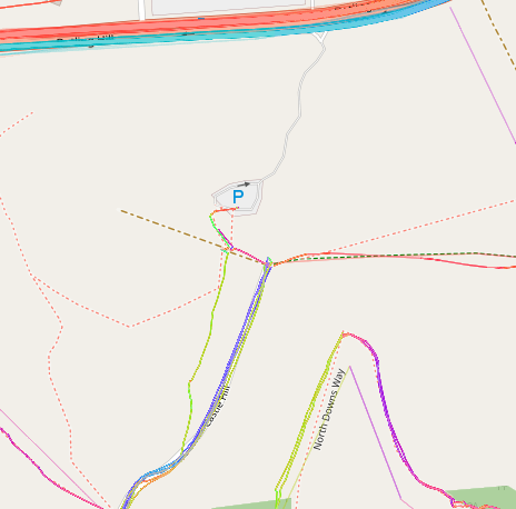 This screenshot shows the GPS trace which I have uploaded, showing the path that needs adding.
Creating your own GPS trace & uploading it
In order to get the best trace possible, make sure you set your device (phone or GPS) to take a reading every second. When you first switch it on, wait for a few seconds so that the device gets an accurate reading - if you are under trees, in a canyon, it’s a cloudy day, or if there is some other problem you may find it takes more than a few seconds. Relax, take your time - you’re doing this for fun and so you can contribute ‘your bit’. The path will still be there in five minutes!