26 Jun 2026
History
My Raspberry Pi4 has been running this site and my nextcloud server for 3 years now, and it’s time it had a rest - Raspberry Pi 5 is on the way!
Current situation
Things have not gone as smoothly as I hoped, and I’m having to rebuild a lot of the site - at the moment most of the links & download links will not work. Please bear with me - hopefully during the course of this weekend I can get it all up & running again.
All should be working fine now - any problems, please let me know.
Any problems, please let me know through my profile on OpenStreetMap
27 May 2026
History
I’ve noticed recently that downloads via the .torrent files has been a bit intermittent, and on further investigation have found that the 2 trackers I’ve been using appear to have been having problems. So…. A solution is in progress.
Trackers
I’ve done some research on trackers, and am now going to be using 3 different trackers, and I’ll also be introducing ‘Magnet Links’.
Torrent Files General Info
A .torrent file is a file you can use to download a shared file over the internet. You will need a bit-torrent app. such as;
For more info on bittorrent, the apps you can use, and general info on the subject, see Wikipedia article at https://en.wikipedia.org/wiki/Comparison_of_BitTorrent_clients
Although I can download and use some of these programmes on my phone, I find it much easier to have a small old raspberry pi computer handling my bittorrent files.
Magnet Links
These are a little time consuming for me to produce, so there will be a gradual introduction of them, starting with the Trike Map, which has been the most popular of late.

The Table (the one on this page is just a screenshot of the actual one) will appear in all of the Garmin Maps info pages, and if the text is coloured (probably blue) then it’s link you can click. If it’s a gmapi or winexe file then it will need to either be a Magnet Link, or select the torrent from the torrent file downloads. The exception is the Avenue Verte files which are so small that all three are offered as direct downloads (Just download the one you want though please!).
Timescale
The Magnet Links are being created and will appear on the site shortly.
On the 1st of June a new batch of all of the maps will be created using the new trackers, and hopefully over the course of the next day or so I will add the new Magnet Links (This is still very much a manual process until I’ve worked out how to automate it!).
Any problems, please let me know through my profile on OpenStreetMap
28 Aug 2025
Preparation
If you’re preparing to do a survey, it’s helpful to do a little preparation, so, make it worthwhile. As well as surveying barriers that need fixing, I also look out for other things to ‘fix’.

The above image shows a kissing-gate identified on a ‘barriers filtered’ map as requiring more details.
The image below shows a shop called ‘Angel Bakes’ which has been identified on https://osm.mathmos.net/survey/#5/55.500/-4.000 as requiring a survey because the fhrs reference had changed - more about this later. As I will be going past this shop on the way to the barrier, it makes sense to stop outside and see what, if anything, needs updating. I normally go out with a list of things to look at, but will find additional things that should be improved whilst out.
One of my other sources of places to survey is https://gregrs.dev.openstreetmap.org/fhodot/ I will only update OpenStreetMap once I’ve made sure that the place I’m updating is still there, and that I’ve seen it in the last week.

Surveying kit
Although I love gadgets and apps, my basic mapping kit is just that ‘basic’ - experience has taught me that a basic mapping kit which includes a notebook and a pencil is wonderfully dependable! The tape measure is cheap and lightweight, and doesn’t have any sharp corners to cut holes into my clothes - about 1.5 metres long (anything longer can be measured with an app on my mobile phone (StreetMeasure - ARCore). Pencils always seem to work, even when wet, and I always add a waterproof notebook into my Xmas wish list. I have some wonderful waterproof pens that write upside down in space - but they also seem able to walk, whereas the pencil doesn’t. My gps is an old and battered Garmin Etrex 30, but you can get similar results using one of Garmin’s other models - I sometimes use a cycle computer when surveying, or use one of the apps on my phone.
My mobile phone will have at least the following apps on it;

Depending on where I’m going, how long I’m going to be out, and the weather, I may also be carrying a waterproof, sun block, hat of some kind, first aid kit, and power bank (using the apps continually is a big drain on a mobile phone’s battery). Need I say cash for coffee & snacks, packed lunch and a drink?
Surveying the Kissing Gate
Turn the gps on at an early stage, so that by the time you get to the barrier it has locked into the best available satellites, and it’s location should be fairly accurate (It might still be ‘out’ by up to 20 metres though!).
When you get to the barrier, create a waypoint - on my etrex I press and hold the ‘joystick’ button, and a numbered waypoint will be created.

A couple of quick notes in the notebook -

Expanding on my scrappy note: 240 KG SQ OP130 Recess 112 translates to;
- waypoint 240
- Kissing Gate
- SQuare_profile
- OP130 refers to the opening but will be used in OSM tagging as maxwidth:physical https://wiki.openstreetmap.org/wiki/Key:maxwidth:physical In most cases it’s the gap between the gate posts.
- Recess 112 - I’m currently using this in relation to kissing gates to represent the gap between the partially open gate, and the back wall of the kissing gate. When you’re passing through the kissing gate, it’s the gap that may be so small you have to take your rucksack off to get through without losing the buttons off your shirt! Kissing Gates designed to allow a horse rider through will have a recess deep enough for a horse to back into.
Angel Bakes » The Village Lunchbox
On my way back I took a couple of photo’s of what had been Angel Bakes (I hope she’s still doing the cakes as well!).


Saving the gps trace
Back home I connect my Garmin Etrex to my computer, run QMapShack, and download the trace to my computer.

Updating OpenstreetMap with iD
In your web browser - Firefox, Google Chrome, Microsoft Edge, Safari, Opera, or ….. load the following tabs;
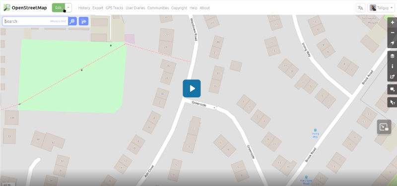
Get the gpx file you created when surveying ready to drag & drop into your web browser. Click on ‘edit’ on the OpenStreetMap tab, then drag & drop your gpx file onto the screen - Follow the sequence in this video - Video can be slow to load. To load, click on the image below.
19 Jul 2025
The Challenge

The Yorkshire 3 Peaks consist of Pen-y-Ghent (694m), Whernside (736m) & Ingleborough (723m), and the walking routes between them mean an overall hike of about 24 miles.
It’s a massive achievement to complete the hike, but some consider the event should be completed in 12 hours.
According to my watch, I completed the hike in 11 hours, 42 minutes, 37 seconds.
SHINE
I was raising funds for SHINE - my just giving page
SHINE is a wonderful charity that has offered advice & very useful information to my daughter about Spina Bifida. They are a small charity, UK based, and when you’re searching for answers about Spina Bifida or Hydrocephalus theirs is the site to visit.
SHINE listed the event as one of their fundraising events - enter through the SHINE website, and you pay a small fee and agree to raise a minimum sum in fund raising, and you then receive their help and support.
Overlimits
SHINE arranged for https://overlimits.co.uk/ to provide the safety information prior to the event, and support on the day. I highly recommend them.
Overlimits monitored the weather conditions, and the forcast was for probably electrical storms (lightning!) probably starting in the afternoon. The team at Overlimits decided that the starting point should be moved from Horton in Ribblesdale to Ribblehead. This meant we would climb the two highest peaks early in the day (Whernside & Ingleborough), and finishing with the long lowland walk back to the starting point - I’m no expert but this struck me as sound thinking! - the safety team would be monitoring the situation, and if at any time there was any suggestion of lightning on the mountains, the safest option would be taken (don’t go up there!).
I carried out a recce. of the start the day before the event - weather was a bit different!
 Ribblehead Viaduct on a sunny day - Whernside in the background.
In the event, there was lots of rain on the day, but no electrical activity.
On the Day
Because I was essentially on my own, and couldn’t be sure of who I would find on the route I decided that the safest option was to dress for, and carry equipment for, a hike. My plan was to try to find others about the same speed. I also wasn’t entirely happy that I wasn’t going to suffer problems with any of a number of bits of my body that are wearing out!
I knew that https://overlimits.co.uk/ were providing marshals on the route, and I was pleased to see that they were all clearly marked, and each had an allocated pace they walked at - some may have been running, because they seemed to set off with the faster participants.
It wasn’t easy! It rained most, if not all, of the day, and it was humid - wear the waterproof and sweat, or don’t wear the waterproof, you still sweat but the rain didn’t make you cold. Some of the hiking involved being on hands and knees and scrambling up rocks. It wasn’t always easy to see the exact route, and on Pen-y-Ghent I think I made my own route near the top as I couldn’t see which of the piles of rocks was the one I should be climbing over - got very muddy hands.
I started near the back, and slowly until I felt sufficiently ‘warmed up’ to increase my pace. By the time I reached the top of Whernside I had overtaken many people, and spotted one of the marshals who seemed to be going at about the right pace. There were also several other participants with a similar pace to mine.
Navigation was mainly fairly simple as the route was well marked, most of the way. I was carrying a handheld GPS with a map and .gpx route on it, which I consulted in places where there seemed to be any doubt. I also had the route on my phone, but knew my phone would not keep going all day if used for navigation - it’s also not built to spend all day in the rain, so it spent most of the day in a plastic bag to keep it safe. The GPS was very useful on a couple of the mountain peaks, as the cloud had come down and in places visibility was down to about 60 metres / yards. It was also nice to be able to see my average speed etc on the GPS so I could tell if I was likely to finish in the 12 hours time which was my target.
Despite the weather, I enjoyed my day, and had a terrific sense of achievement in finishing - finishing in less than 12 hours was an additional bonus. The pint of beer in the Station Inn at Ribblehead was very, very welcome! I met & chatted with many nice people on the route - all were raising funds for very worthwhile charites, and their back stories were inspiring - thank you all, and to the team from https://overlimits.co.uk/.
 Me at the end, resplendent in a dry ‘T’ shirt I’d carefully carried in a plastic bag.
A few photo’s from round the route.


28 Jun 2025

All mapping data is derived from OpenStreetMap, including the downloadable maps. Many thanks to OpenStreetMap contributors for their skill & dedication.
Everything here is freely available, but there are no guarantees that it will work. You’re still responsible for following the laws of the land, and the rules of the road. Data here, and on the maps, may be wrong, or out of date! I hope it helps you, but can’t guarantee it
Table of Contents
About
Designed for an electric wheelchair 0.72 metres wide, and 1.36 metres long.
I have a friend with a son who uses an electric wheelchair. In the past they’ve driven to a park somewhere, and then found they couldn’t get the wheelchair out of the car park.
Hopefully this will help you to decide what your route should be.
Icons
The main icons are described below. At higher zoom levels all you see is the icon, as you zoom in details of the barrier will appear.
 This icon represents a barrier which has been updated with all tags describing its type, and, if needed, sizes of any openings. The barrier there will probably block your route and prevent you going further.
This is the criteria used in creating this map (with links to the OpenStreetMap wiki entry concerning the barrier);
- 2 or more steps,
- a stile of whatever type,
- a kissing gate - there are two types of kissing gates that may possibly allow passage, and they are mapped according to the available gaps (Large Square Profile, and Large Circular Profile),
- A bollard or block with a gap allowing passage of less than 0.72 metres
- A gap / entrance designed to allow access, or a gate with a width of less than 0.72 metres,
- Cycle_barrier - there are several different types. A double or treble will be difficult to negotiate with an electric wheelchair. Not only the available width, but also the spacing between the barrier parts will be significant. If the spacing is less than 1.36 metres, they are marked with the
 This icon is used when the tagging is incomplete - we can’t be sure if this will block your progress or not. Adding the missing tags on OpenStreetMap is needed.
.
Public and Private
This map only shows those barriers which are in a Public area, or which have a Public Highway on them - if a driveway is marked as having a gate, but the driveway or gate is marked as ‘Private’ then this is not shown on this map.
I’ve included routes & barriers which are on paths, bridleways, tracks & highways (roads), as long as they are not marked as private, or for customers only.
.
Using the maps
Although this map is made for a Garmin device, you will find it is best used to plan your journey before you get there!
Using the map on a computer;
Using the map on an Android phone;
Using the map on a Garmin Device


-
Garmin etrex devices - make sure you choose a device that uses a microSD card to hold the map. Set the navigation mode to Cycle or bicycle. It’s a small screen, but manages well and there are lots of options for functionality. Personally I use an old ‘etrex’ as my main means of collecting mappng date - mine has the barrier map loaded, and when I reach a barrier I wish to update, I create a waypoint there and then make notes in a small notebook, with the waypoint number as a reference.
-
Garmin Edge devices - make sure you choose a device that uses a microSD card to hold the map. Small screen, but they are surprisingly versatile. I have several different ones that I bought cheap & used (less than £50 each), my favourite is probably an edge 810, but even my very old 605 and 705 devices are capable of displaying the maps at walking or cycling speed. Waypoints can be created using the ‘lap’ button (may need setting up in the system settings).
microSD card Don’t spend a fortune. You don’t need the fastest microSD cards, but they do need to be at least class 4
Routing
If you are using this map on a laptop or computer, please be aware that the routing you will see is probably based upon a website, using a programme called ‘brouter’, or ‘Routino’, or some other online router - if you’re looking on a phone, if there is internet access it will also use one of these online routing programmes.
Once the map is installed on a Garmin device, the routing should follow the rules I have set;
is avoided.
These may, or may not be a problem, so the routing does not avoid them.
.
Updates
For information about any recent updates, and any intended updates, please see:
I’d welcome any suggestions for changes, or requests for a slightly different map - Create an Issue making it plain to me what you require.
New Versions of the Maps
All of the information displayed in the maps is derived from:
Although OpenStreetMap (OSM) updates almost immediatly after any changes, I only update my data at intervals. The date gives a clue as to how ‘new’ the data is. For instance trike-2025-07-01.7z was created on the 01/07/2025, but the data will be from the 30/06/2025 - about 9pm. It takes several hours for all of the maps to be updated, and for me to carry out quick checks - if you want to get the lates version of any map, the safest option is to wait until about 3pm by which time the new map should be available.
When I’m working on a map, I often create an ‘interim’ version, which include the changes I’ve just made - these are created using OpenStreetMap data from my most recent update.
I download updates every Thursday, and the 1st of every month.
The Barriers Filtered map shows only barriers on OpenStreetMap that need updating, and if you would like to help update these maps, this is the map to download and check to see what needs doing. It’s updated every Thursday.
See the information about the individual map for details of what is shown and why.
To update OpenstreetMap go to the OSM site, setup an account, and then use one of the following;
-
StreetComplete - Available only for Android devices at the moment (July 2025), but there are plans to make it available for other devices as well. Easy & quick to use. If I get time I’ll add more detail, or a section on using it.
-
Carry a small notebook, pencil and tape measure. Take measurements, and use these to update OSM - go to the OSM site, login, zoom to the area you want to edit, then click on edit and follow the instructions. The OSM WIki at https://wiki.openstreetmap.org/ has helpful details about starting out. For example see Surveying & Updating a Kissing Gate
-
Vespucci - A fully featured OpenStreetMap editor on your phone!
-
Osmand - actually an app for navigation, but you can also carry out some limited editing using it - I use it for adding some points.
-
OSMTracker - Very useful for taking detailed ‘gpx’ notes that you later use with a laptop / desktop computer editor to update OpenStreetMap.
It’s worth searching on your phone’s app. store - there are many apps I am not aware of
Can you help?
Help is always very welcome!
A few options for you;
Update OpenStreetMap
Details are in the previous section.
Donations to Charity
I’m usually trying to raise funds for a charity - currently I’m aiming to complete a sponsored Yorkshire Three Peaks Challenge, and am raising funds for https://www.shinecharity.org.uk/
My donation page if you’d like to donate is https://www.justgiving.com/page/nick-allen-3?utm_medium=FR&utm_source=CL
Downloads
Downloading - Click Once!
Verifying the integrity of your download
Using my linux computer the command: md5sum trike-2026-02-01.7z
produced the result:
60e12c4b599077a74d616a5938e9926d trike-2026-02-01.7z
If you have any doubt at all about the integrity of your download, please use this basic integrity check of the download, checking the result you get is identical to the result in this list;
For downloading a single file using a bit-torrent program, use the Magnet Link below, or to download all of the bit-torrent files, click this link >: https://daphne-nick.uk/nextcloud/index.php/s/6cQesAz38DWRWBo.
Use the -gmapi- version for Apple/Mac computers (maybe Windows as well? Use the -winexe- version for …. well. Windows!
MD5sums & Magnet Links
Feedback
I’d welcome feedback through either;
Why do I do this?
I ride a recumbent trike (long story, but I’ve had surgery on both wrists and can no longer ride a ‘normal bike’),
I have friends with a son who uses an electric wheelchair - before now they have visited a park, only to find that the electric wheelchair couldn’t get out of the car park!
I have a granddaughter who was born with Spina Bifida, and we don’t know what the future holds for her. https://www.shinecharity.org.uk/ were, and are, particularly helpful. My daughter’s blog makes interesting reading https://www.facebook.com/p/Jelly-Beans-Journey-with-Spina-Bifida-61552088571793/
Credits
A brief list of those volunteers / organisations making this possible;
-
OpenStreetMap contributors - none of this would be possible without them!
-
MKGMAP - This is the java command line app that I use to produce the maps.
-
Numerous opensource software packages used in the preparation of the maps, and this website!
Thanks for reading!