12 Dec 2023
</! Categories were [OpenStreetMap, Garmin-Maps, Cycling] />
All mapping data is derived from OpenStreetMap, including the downloadable maps. Many thanks to OpenStreetMap contributors for their skill & dedication.
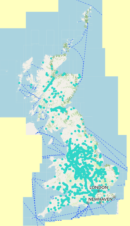
New - Cycle Map of GB

I’ve just finished creating and testing this new map with the following features:
- National cycle routes are shown in bold red,
- Regional cycle routes are bold pink,
- Local cycle routes are blue,
- References for the cycle routes are displayed, often in a ‘shield’,
- This is a lightweight style, aimed at use on a cycle computer, and a number of changes have been made to ensure it responds quickly on a cycle computer, and that information important to a cyclist is displayed,
- Buildings are not shown,
- Gardens are not shown,
- Icons for many features not needing to be seen by a cyclist are not shown, for instance an icon for a carpet shop,
- Motorways, and other main roads that cyclists usually avoid are shown in grey,
- As cycle parking places are now so frequent, I have not shown them as in dense areas they can clutter the map so much it becomes confusing,
- Cycle shops, and those shops which sell cycle items used by cyclists, are shown,
- Parkrun starting points are shown, where they have been added to OpenStreetMap,
- Postboxes are shown, with their collection time, if available,
- The map is both routable, and searchable,
- Available as:
- for windows users cycle-winexe-2023-12-12.7z.torrent,
- for apple and windows users cycle-gmapi-2023-12-12.7z.torrent,
- for those using QMapShack, or who only wish to install the map on their Garmin device, cycle-2023-12-12.7z.torrent.
Available from
https://daphne-nick.uk/nextcloud/index.php/s/6cQesAz38DWRWBo
Each of the different variety (exe, gmapi, or gmapsupp & tdb) are compressed with 7-zip, but are still approaching 600mb in size, and are supplied as a torrent file, which will allow you to download the complete file.
See https://daphne-nick.uk/openstreetmap/garmin-maps/2023/10/18/garmin-map-instructions for instructions on using the files.
This map will be updated on a monthly basis whenever possible, with a new version created on the first Tuesday of the month, and posted on my site for download as soon as I have tested it, often the same day.
Screenshots - Garmin Edge 810


Screenshots - Garmin Basecamp


Screenshots - QMapShack


22 Nov 2023
All mapping data is derived from OpenStreetMap, including the downloadable maps. Many thanks to OpenStreetMap contributors for their skill & dedication.
Linux, Windows & Apple Mac user updates

You will start to see the following changes on the download site, being gradually phased in from now, with the aim of all maps being available in these formats in the future. As usual, your starting point is the download site at
https://daphne-nick.uk/nextcloud/index.php/s/6cQesAz38DWRWBo
Linux Users
Filename is now in the form north_downs_way_2023-11-22.7z, or for those maps of over 500mb in size ave-verte-w-europe-2023-11-07.7z.torrent. Use the instructions from https://daphne-nick.uk/openstreetmap/garmin-maps/2023/10/18/garmin-map-instructions/ which explain how to deal with torrent files. When you download a file it’s polite to continue to ‘seed’ it for a while.
Microsoft Windows User Updates (.exe)


Filename is now in the form north_downs_way-winexe-2023-11-22.7z, which you can download to your Microsoft Windows computer. When you unzip it you will have a file with a name similar to Tallguy-North-Downs-Way.exe, unzip it and then run by double clicking the *.exe file which is inside. If you use both Windows & Apple Mac you may find the gmapi option below to be easier.
Apple Mac Users (.gmapi)
Filename is in the form north_downs_way-gmapi-2023-11-22.7z which you can download, unzip & then copy the complete directory tree into
{user}\AppData\Roaming\Garmin\Maps
or
\ProgramData\Garmin\Maps
and the map will be available to Garmin PC programs. This will also work for Windows users.

18 Oct 2023
All mapping data is derived from OpenStreetMap, including the downloadable maps. Many thanks to OpenStreetMap contributors for their skill & dedication.
Viewing the available maps
All of the maps from this site are freely available, but you have to download them and install them yourself. When you click on the link to the download site:
https://daphne-nick.uk/nextcloud/index.php/s/6cQesAz38DWRWBo
You should be presented with something similar to this view.

If your view is the one shown below you need to update your browser, or use a newer browser such as Firefox or Chrome (Chromium). Do not “Download all files” - there could be many Gigabyte’s of maps that you do not want, and it will swamp your internet connection, and probably mine as well.

Types of file / Map available
Because we are talking very big file sizes, my home network will not manage to allow everyone to download very large maps, directly, so I need to ask people to share the download of the larger files, using a file sharing platform.
 Bit-Torrent
Having decided which file you want to download, click on the filename, the download will begin, and the filename will appear in your download list. This will be very quick if you are downloading a *.7z.torrent.
Smaller Garmin compatible maps - “Small Avenue Verte” etc..
Smaller maps such as the “Small Avenue Verte” or “North Downs Way” are supplied as a direct download, compressed with 7-zip.
Garmin compatible maps supplied as a torrent file
Anything larger than 500mb is supplied in the form of a torrent file - the filename will be similar to “ave_verte_w_europe_20231009.7z.torrent” or “can_av_nsc_ndw_20231016.7z.torrent”.


Instructions for Windows users
Torrent Files
If you’ve downloaded a *.torrent file, you will now need to load it into a Bit-torrent programme, such as Transmission or Deluge, and wait for that download to complete - when that is complete, and it could take a long time (or if many people are downloading then it could be very quick!). If you search on the internet you should be able to find a suitable bit-torrent programme to install & use.
Decompressing your .7z download
You will need one of the programmes on your computer that can deal with files that have been compressed with 7-zip - I use the one from https://www.7-zip.org/download.html.
Using your file manager right click on the files name, and select “7-zip” & “Extract here”.

Instructions for Ubuntu (Linux users)
Torrent Files
Transmission is available in the Ubuntu Software Boutique, or you can choose from a variety of other apps. using
Decompressing your .7z download
A suitable programme for dealing with 7-zipped archives is probably already installed on your computer as part of the archive manager, and when your download is complete, right click on the filename in the file manager and select ‘extract here’, or choose a suitable location.
Using the files
You will now have two files, in a folder, for example;
- ave_verte_w_europe_20231009.img , and
- ave_verte_w_europe_20231009.tdb
Keep the two files together as they are both needed if you intend to use the map on Garmin’s free ‘Basecamp’ programme. QMapShack is another good alternative for desktop use using the garmin compatible map (https://github.com/Maproom/qmapshack/wiki).
Follow this guide if you need help loading the maps into your Garmin device:
https://wiki.openstreetmap.org/wiki/OSM_Map_On_Garmin#Installing_the_map_onto_your_GPS
If you wish to contact me - feedback about any of these maps is always welcome, please do so through:
https://www.openstreetmap.org/user/Tallguy
04 Aug 2023
Combined Garmin Compatible Map
</! Categories were [OpenStreetMap, Cycling, Walking, Garmin-Maps, Canal] />
No longer being produced - message me if you would like me to resume producing it.
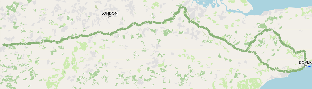
This extends to an area covering most of Great Britain, and within that area shows the routes of;
The Avenue Verte within GB,The North Downs Way walking route,The North Sea Cycle route within GB, andMany canal features, such as locks, bridge numbers & names, winding holes, and water points.
All mapping data is derived from OpenStreetMap, including the downloadable maps. Many thanks to OpenStreetMap contributors for their skill & dedication.
If you wish to contact me - feedback about any of these maps is always welcome, please do so through:
https://www.openstreetmap.org/user/Tallguy
03 Aug 2023
No longer being produced - March 2024
All mapping data is derived from OpenStreetMap, including the downloadable maps. Many thanks to OpenStreetMap contributors for their skill & dedication.
</! these are the categories that were in use [OpenStreetMap, Walking, Garmin-Maps] />
Link for all Downloads
All maps are available from
https://daphne-nick.uk/nextcloud/index.php/s/6cQesAz38DWRWBo
either as a direct download if the file is less than 500mb in size, or as a torrent link (it’s saved as a .7z because my nextcloud server will only handle it if it is zipped - extract it and then open with your torrent programme).
All dates {DATE} are in the format YYYYMMDD.
All maps also show the start position for Parkruns (where available).
These maps have been tested on:
- Garmin Edge 530 (no microSD card slot. The small file was copied to the internal memory - search on internet for ‘how’- at your own risk).
- Garmin Edge 810
- Garmin Edge Touring
- Garmin Edge 605 & 705
- Garmin Etrex 30
- Garmin Basecamp
- QMapShack
The maps are updated every month, depending on my availability.
You will need a torrent sharing programme on your computer, such as Transmission or Deluge (there are many, just search on the internet if you haven’t come across them before). There is a guide to installing maps onto your Garmin device here. If all of this sounds very complicated to you, and you just want to buy one of these maps already installed onto a microSD card, I do offer them for sale on ebay - listing links are with the map details below.
North Downs Way - Garmin compatible map
File name = north_downs_way_{DATE}.7z (These files are less than 50mb in size and are available as a direct download).
If you wish to contact me - feedback about any of these maps is always welcome, please do so through:
https://www.openstreetmap.org/user/Tallguy